About VFRnav flight navigation
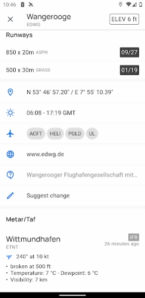
The integrated database includes airfields from Germany, Austria, Switzerland as well as BeNeLux, France, Italy, the Czech Republic and Poland and many other countries with information about name, frequency and runway...
The integrated database includes airfields from Germany, Austria, Switzerland as well as BeNeLux, France, Italy, the Czech Republic and Poland and many other countries with information about name, frequency and runway data.
After the setup, VFRnav works completely offline and does not need an existing data connection for navigation at any time.
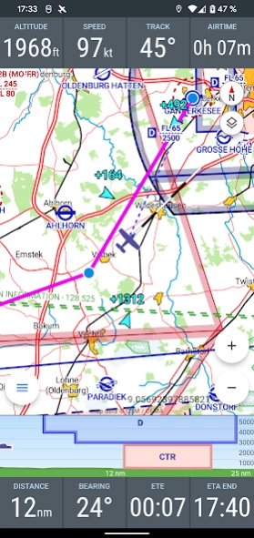
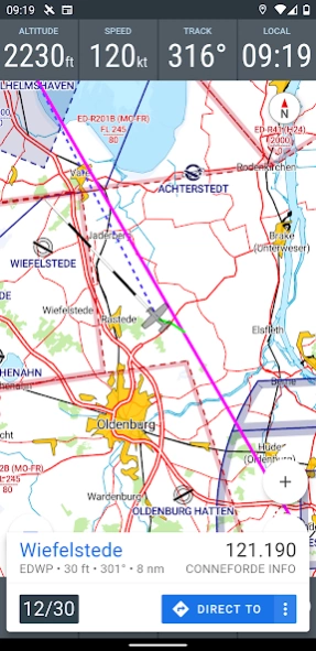
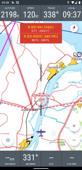
The integrated flight planning helps with route planning, the calculation of fuel and flight times and automatically provides information about flight weather (metar & taf) and notams enroute.
The flight log enables the digital recording of your flights. Thanks to the automatic flight time recording, all flights are automatically recorded. Tracks can be exported as KML files and sent by email. Flown routes can thus be easily displayed e.g. on Google Maps.
For high requirements, VFRnav can process position data from external GPS receivers via Wifi or Bluetooth. Traffic data is also processed and displayed directly on the map. VFRnav works with many FLARM and ADS-B devices. Stratux is also supported.
The development of VFRnav takes place in close contact with pilots in europe. In the current version 3, many ideas and suggestions have been implemented that have reached us by e-mail in the past few months. Many thanks at this point for all the feedback.
VFRnav is compatible with traffic data sources such as SafeSky, CCAS, Stratux, AT-01, FLARM, etc.
All functions of VFRnav can be tested without restrictions. If you like VFRnav, you can purchase a license for 49.95 €. You will receive all updates free of charge for one year. After 12 months have expired, the update period can be extended for just 29.80 €. However, VFRnav itself can run indefinitely.
By the way: The license is personal, but not device-specific. If you use several Android devices under the same Google account, the full version is available on all devices (maximum of three devices).
Note: For the map and airspace display, at least 200MB of free storage space must be available. Compatible with devices from Android 5. A minimum resolution of 480x800 pixels is recommended.
Disclaimer of liability: Please note that VFRnav is not an officially approved aid for flight preparation and execution. A guarantee for the correctness and completeness of the data is excluded. Please always check the data displayed with official aviation maps.
Previous Versions
Here you can find the changelog of VFRnav flight navigation since it was posted on our website on 2016-12-28 02:29:47.
The latest version is 4.1.2 and it was updated on 2024-04-01 13:41:38. See below the changes in each version.
VFRnav flight navigation version 4.1.2
Updated At: 2024-03-14
VFRnav flight navigation version 4.0.6
Updated At: 2024-01-24
Changes: v4.0.6
Fix: double traffic
Fix: Language
New: Ui Dark mode
New: significant user interface optimizations
New: Help text
New: Flight export as text (share)
New: Tablet ui mode
New: NOTAM translations
Fix: Notam display
Fix: excel import/export
v3.41.0
notam display improved
map improved
better support for font size changes
improved excel in/export
Fix: several bug fixes and performance improvements
VFRnav flight navigation version 4.0.5
Updated At: 2024-01-11
Changes: v4.0.5
Fix: double traffic
Fix: Language
New: Ui Dark mode
New: significant user interface optimizations
New: Help text
New: Flight export as text (share)
New: Tablet ui mode
New: NOTAM translations
Fix: Notam display
Fix: excel import/export
v3.41.0
notam display improved
map improved
better support for font size changes
improved excel in/export
Fix: several bug fixes and performance improvements
VFRnav flight navigation version 3.39.0
Updated At: 2023-08-22
Changes: v3.39.0
New: search for saved routes
v3.38.0
Fix: restore location after start
v3.37.4
New: Simplified/Automatic connection to location and traffic sources
New: option to show traffic id on map
Fix: Mode S altitude reference
Fix: X-Plane 11/12 support
Fix: TMA airspace display
VFRnav flight navigation version
Updated At: 2021-06-30
Changes: v3.8.1
New: NMEA/FLARM via UDP
Fix: SkyEcho traffic no altitude
Fix: tcp connection after wifi lost
Fix: faster map updates
v3.7.1
Fix: Route loading dialog
Fix: airspace GND label on map
Increased chart border width
Increased compatibility for custom openAir 'Platzrunden' file
v3.6.3
Fix: SwiftKey form input
Fix: Route import dialog scrolling
VFRnav flight navigation version
Updated At: 2021-06-20
Changes: v3.7.1
Fix: Route loading dialog
Fix: airspace GND label on map
Increased chart border width
Increased compatibility for custom openAir 'Platzrunden' file
v3.6.3
Fix: SwiftKey form input
Fix: Route import dialog scrolling
v3.6.1
New: glider symbol
Traffic relative altitude textsize improved
Neu: Support for route planning via charts.aero
v3.5.6
New: FS2020 support
Fix: Metar/Taf view missing visibility value
Fix: landscape layout
VFRnav flight navigation version
Updated At: 2021-06-17
Changes: v3.7.0
Fix: Route loading dialog
Fix: airspace GND label on map
Increased chart border width
Increased compatibility for custom openAir 'Platzrunden' file
v3.6.3
Fix: SwiftKey form input
Fix: Route import dialog scrolling
v3.6.1
New: glider symbol
Traffic relative altitude textsize improved
Neu: Support for route planning via charts.aero
v3.5.6
New: FS2020 support
Fix: Metar/Taf view missing visibility value
Fix: landscape layout
VFRnav flight navigation version
Updated At: 2021-06-06
Changes: v3.6.3
Fix: SwiftKey form input
Fix: Route import dialog scrolling
v3.6.1
New: glider symbol
Traffic relative altitude textsize improved
Neu: Support for route planning via charts.aero
v3.5.6
New: FS2020 support
Fix: Metar/Taf view missing visibility value
Fix: landscape layout
v3.5.2
Fix: inport/export of waypoints
time input fields improved
Fix: wrong name in waypoint widget
Fix: aircraft input form improved
VFRnav flight navigation version
Updated At: 2021-05-26
Changes: v3.6.1
New: glider symbol
Traffic relative altitude textsize improved
Neu: Support for route planning via charts.aero
v3.5.6
New: FS2020 support
Fix: Metar/Taf view missing visibility value
Fix: landscape layout
v3.5.2
Fix: inport/export of waypoints
time input fields improved
Fix: wrong name in waypoint widget
Fix: aircraft input form improved
VFRnav flight navigation version
Updated At: 2021-05-17
Changes: v3.5.6
New: FS2020 support
Fix: Metar/Taf view missing visibility value
Fix: landscape layout
v3.5.2
Fix: inport/export of waypoints
time input fields improved
Fix: wrong name in waypoint widget
Fix: aircraft input form improved
v3.3.1
- Fix: Routecalculation by missing fuel
- Fix: improved gps on some devices
- Fix: external airspace data loading failed
- flight form improved
Disclaimer
Official Google Play Link
We do not host VFRnav flight navigation on our servers. We did not scan it for viruses, adware, spyware or other type of malware. This app is hosted by Google and passed their terms and conditions to be listed there. We recommend caution when installing it.
The Google Play link for VFRnav flight navigation is provided to you by apps112.com without any warranties, representations or guarantees of any kind, so access it at your own risk.
If you have questions regarding this particular app contact the publisher directly. For questions about the functionalities of apps112.com contact us.